NEARBY TOWN/CITY: Wanaka
DISTANCE FROM TOWN CENTRE: The run can be started in the heart of the Metropolis or just 6 kms from the town centre.
START LOCATION: Lake front, Wanaka (full run) or Roys Peak car park on Mt. Aspiring Rd, 6 kms from town centre (shorter version)
TOTAL ROUTE DISTANCE: Full run 30.2 kms, Shorter option 23 kms
TIME TO RUN: Full run: Elite 3½ hours; Novice 7 hrs. Take 30 mins to an hour off for the shorter version.
TOTAL ASCENT (if known): 1,600 metres TOTAL DESCENT (if known): 1,500 metres (pretty much the same for both the full run and the shorter version)
TYPE OF TRAIL RUN: Point to point
DIFFICULTY: Moderate – Hard
DEFINING CHARACTERISTICS: Open travel on mostly well-made tramping and farm tracks. One fairly technical section along the ridge line.
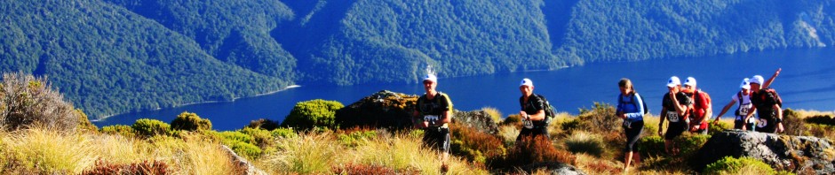
FEATURES OF INTEREST: Stunning views, stunning views and more stunning views.
ONLINE REFERENCE: View the run in detail on Garmin Connect
BEST MAP/S: Topomap F40
RUN IT:
Start from the ‘Log Cabin’ Information Centre on the lake front in Wanaka, head west along the lake shore on the footpath or beach. A little over a km of pleasant running brings you to a wee footbridge over a small creek and the start of the Millennium Track.
Follow the Millennium Track along the side of the lake, pass through Waterfall Creek car park and keep heading away from town. A little over 4 kms from the start of the Millennium Track (about 5.6 kms from the Log Cabin) turn off left on a track signed “Mt Roy Track”. Follow the path and orange marker poles across farmland before turning right on to Mt. Aspiring Road. About 350m away is the car park and access to Roys Peak track.
You now start climbing and you won’t stop for a very long time! It’s a 1,230m climb on a zig-zag 4WD track to the summit, but the views are breathtaking and a great excuse to stop every now and again.
The next section is more technical and can be very exposed – not advisable in bad weather or winter conditions unless you really know what you are doing. From Roys Peak head south along the ridge, following the tramping track and marker poles down to a saddle and back up to Mt.Alpha. It’s an awesome section of ridge, but parts are pretty much unrunnable. Take your time, enjoy the views.
From the summit of Mt Alpha follow the poled route east/south-east down the main ridge. 2 kms of sublime running lead you a notch in the ridge just north of pt 979. Here a 4WD track joins from south-west (your right) but it is not particularly well marked so keep a careful eye out for it. Follow this track down. On your left you’ll be looking into the Cardrona Valley (with the Pisa Range beyond) and on your right is Spotts Creek. About 3.5kms after joining the 4WD track it takes a sharp right turn and starts heading down into Spotts Creek.
Once in the valley the track becomes a bit rougher, essentially just a stock track, but is well marked. Follow it downstream, at one point doing a quick double crossing of the creek and climbing in and out of a couple of side creeks.
The route eventually flattens out and bears around towards the Cardrona Valley, at which point you will be running on quite swampy paddocks. Follow the marker poles through a small section of plantation forest, through a deer fence and out to the Cardrona Road.
POST RUN GOODNESS: Wanaka has a great selection of cafes, bars and restaurants for a post-run treat. Or if your support driver can be coaxed into a trip further up the Cardrona Valley the historic Cardrona Hotel provides a convivial setting and awesome potato wedges that will satisfy the hungriest trail hound.
Download this trail guide as a PDF file – Wanaka Skyline Trail


Nice stuff Mal. I was in Wanaka a few months ago running on the trails around there. How I wish I could live there full-time and just run 🙂